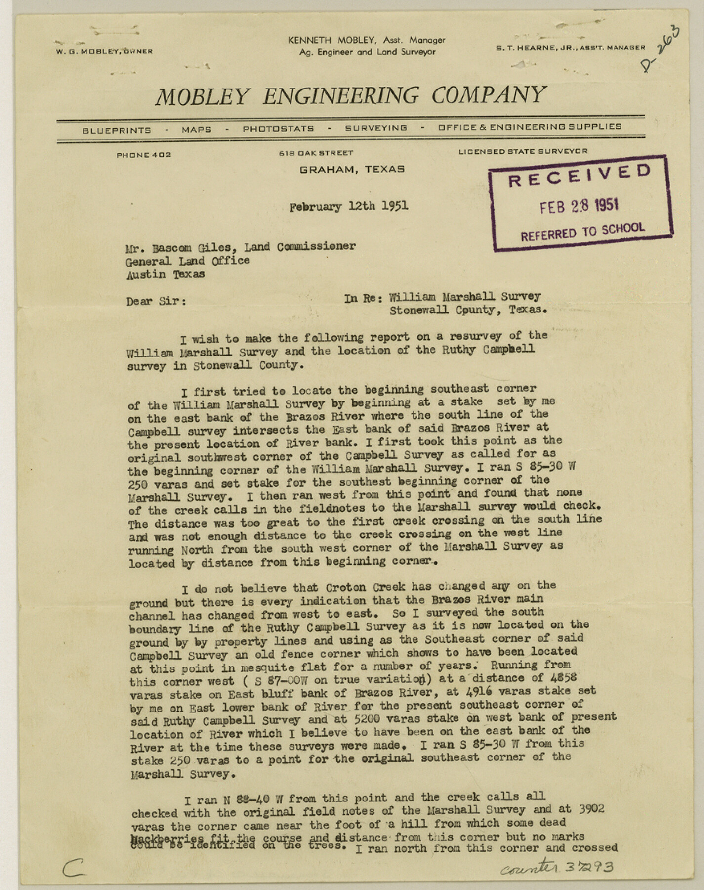
Stonewall County Sketch File 23
[Surveyor's report regarding accretion and corrected field notes in the Wm. Marshall survey]
-
Map/Doc
37293
-
Collection
General Map Collection
-
Object Dates
2/12/1951 (Creation Date)
2/28/1951 (File Date)
-
People and Organizations
W.G. Mobley (Surveyor/Engineer)
-
Counties
Stonewall
-
Subjects
Surveying Sketch File
-
Height x Width
11.3 x 8.9 inches
28.7 x 22.6 cm
-
Medium
paper, print
-
Features
Brazos River
Croton Creek
Part of: General Map Collection
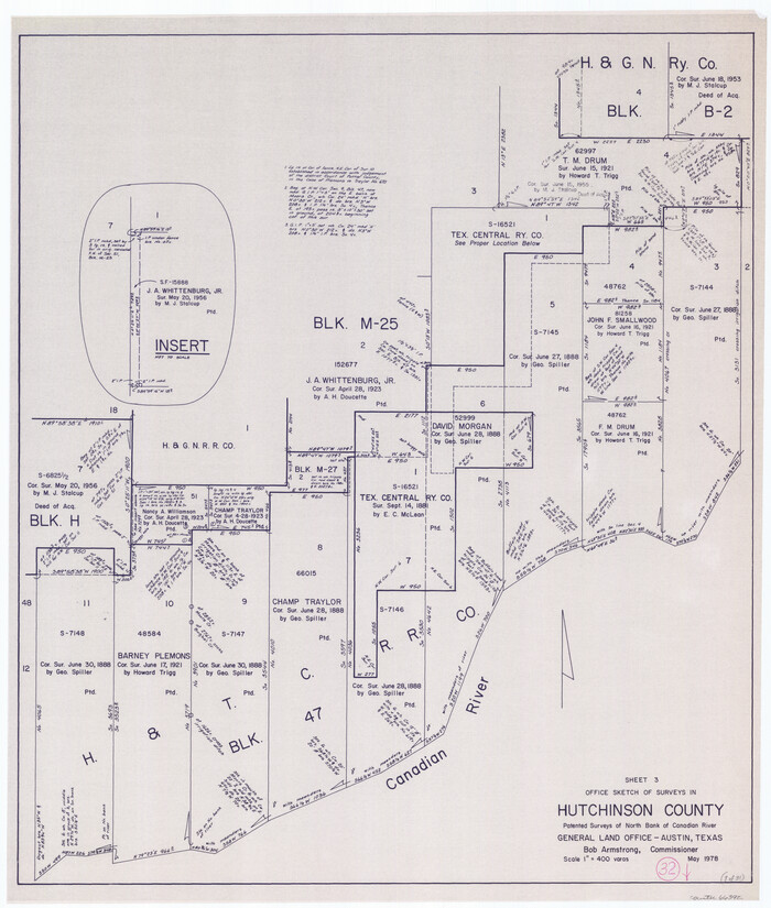
Hutchinson County Working Sketch 32
Print $20.00
- Digital $50.00
Hutchinson County Working Sketch 32
1978
Size 27.8 x 23.6 inches
Map/Doc 66392
Sabine Bank to East Bay including Heald Bank

Print $20.00
- Digital $50.00
Sabine Bank to East Bay including Heald Bank
1957
Size 45.0 x 34.4 inches
Map/Doc 69846
Hutchinson County Sketch File 33

Print $20.00
- Digital $50.00
Hutchinson County Sketch File 33
1926
Size 26.5 x 24.5 inches
Map/Doc 11821
Jeff Davis County Sketch File 25b

Print $20.00
- Digital $50.00
Jeff Davis County Sketch File 25b
Size 18.9 x 20.0 inches
Map/Doc 11861
Nacogdoches County Working Sketch 1

Print $20.00
- Digital $50.00
Nacogdoches County Working Sketch 1
Size 27.8 x 35.8 inches
Map/Doc 71217
Sterling County Rolled Sketch 11

Print $20.00
- Digital $50.00
Sterling County Rolled Sketch 11
1884
Size 22.5 x 46.6 inches
Map/Doc 9945
Energy Map of Texas

Print $20.00
- Digital $50.00
Energy Map of Texas
2020
Size 36.0 x 36.0 inches
Map/Doc 96436
Rio Grande Rectification Project, El Paso and Juarez Valley

Print $20.00
- Digital $50.00
Rio Grande Rectification Project, El Paso and Juarez Valley
1935
Size 10.7 x 29.6 inches
Map/Doc 60862
Map of the County of Cameron, Texas

Print $40.00
- Digital $50.00
Map of the County of Cameron, Texas
1884
Size 54.7 x 34.5 inches
Map/Doc 3141
Rusk County Sketch File 46

Print $4.00
Rusk County Sketch File 46
1846
Size 12.6 x 7.8 inches
Map/Doc 35595
Webb County Sketch File 68

Print $26.00
- Digital $50.00
Webb County Sketch File 68
1952
Size 19.9 x 25.0 inches
Map/Doc 12656
Flight Mission No. DCL-5C, Frame 78, Kenedy County

Print $20.00
- Digital $50.00
Flight Mission No. DCL-5C, Frame 78, Kenedy County
1943
Size 18.7 x 22.5 inches
Map/Doc 85861
You may also like
Potter County Boundary File 3e

Print $6.00
- Digital $50.00
Potter County Boundary File 3e
Size 9.2 x 8.0 inches
Map/Doc 57993
El Paso County Rolled Sketch 38
Print $40.00
- Digital $50.00
El Paso County Rolled Sketch 38
1922
Size 14.1 x 61.3 inches
Map/Doc 8866
Hunt County Sketch File 5a

Print $6.00
- Digital $50.00
Hunt County Sketch File 5a
1852
Size 10.2 x 15.8 inches
Map/Doc 27093
Galveston County Sketch File 43

Print $40.00
- Digital $50.00
Galveston County Sketch File 43
1915
Size 19.4 x 15.1 inches
Map/Doc 11539
Mustang Island

Print $20.00
- Digital $50.00
Mustang Island
1945
Size 42.8 x 42.6 inches
Map/Doc 77469
Map of Mitchell County, Texas

Print $20.00
Map of Mitchell County, Texas
1890
Size 23.4 x 18.9 inches
Map/Doc 88980
Flight Mission No. DCL-6C, Frame 120, Kenedy County

Print $20.00
- Digital $50.00
Flight Mission No. DCL-6C, Frame 120, Kenedy County
1943
Size 18.4 x 22.3 inches
Map/Doc 85950
Montgomery County Rolled Sketch 38

Print $40.00
- Digital $50.00
Montgomery County Rolled Sketch 38
1962
Size 56.0 x 30.8 inches
Map/Doc 9545
E. R. Allen Irrigated Farm SE Quarter Section 21, Block E

Print $3.00
- Digital $50.00
E. R. Allen Irrigated Farm SE Quarter Section 21, Block E
Size 10.3 x 14.3 inches
Map/Doc 92319
A Map of Texas published by the Dallas Morning News for the Texas Almanac and State Industrial Guide

A Map of Texas published by the Dallas Morning News for the Texas Almanac and State Industrial Guide
1936
Size 20.3 x 26.1 inches
Map/Doc 94293
[T. & P. Block 44, Township 2S]
![90949, [T. & P. Block 44, Township 2S], Twichell Survey Records](https://historictexasmaps.com/wmedia_w700/maps/90949-1.tif.jpg)
Print $20.00
- Digital $50.00
[T. & P. Block 44, Township 2S]
Size 10.0 x 21.9 inches
Map/Doc 90949
Jasper County Sketch File 19

Print $6.00
- Digital $50.00
Jasper County Sketch File 19
1890
Size 14.2 x 8.8 inches
Map/Doc 27815