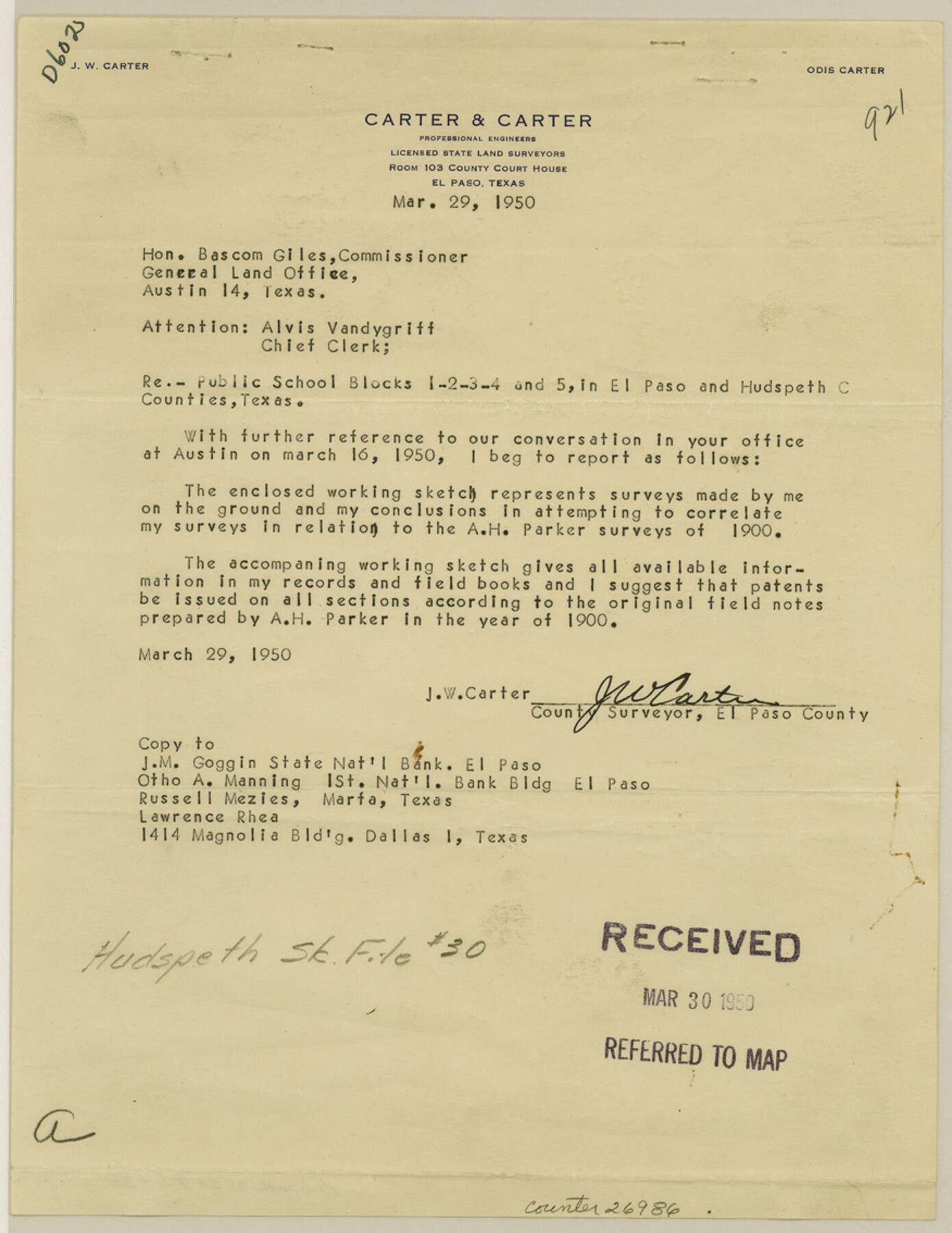
Hudspeth County Sketch File 30
[Sketch and letter regarding PSL Blocks 1, 2, 3, 4, 5 in Hudspeth and El Paso Counties]
-
Map/Doc
26986
-
Collection
General Map Collection
-
Object Dates
3/29/1950 (Creation Date)
4/6/1950 (File Date)
3/29/1950 (Correspondence Date)
1900 (Survey Date)
11/25/1919 (Survey Date)
3/20/1950 (Survey Date)
9/6/1944 (Survey Date)
5/1919 (Survey Date)
-
People and Organizations
J.W. Carter (Surveyor/Engineer)
A.H. Parker (Surveyor/Engineer)
-
Counties
Hudspeth El Paso
-
Subjects
Surveying Sketch File
-
Height x Width
11.3 x 8.8 inches
28.7 x 22.4 cm
-
Medium
multi-page, multi-format
Part of: General Map Collection
[Gulf Coast portion of] Map of the State of Texas
![72707, [Gulf Coast portion of] Map of the State of Texas, General Map Collection](https://historictexasmaps.com/wmedia_w700/maps/72707.tif.jpg)
Print $20.00
- Digital $50.00
[Gulf Coast portion of] Map of the State of Texas
1865
Size 27.4 x 18.1 inches
Map/Doc 72707
[Part of Bexar District]
![1958, [Part of Bexar District], General Map Collection](https://historictexasmaps.com/wmedia_w700/maps/1958-1.tif.jpg)
Print $20.00
- Digital $50.00
[Part of Bexar District]
1847
Size 40.9 x 27.8 inches
Map/Doc 1958


Bosque County Sketch File 4

Print $4.00
- Digital $50.00
Bosque County Sketch File 4
1854
Size 11.3 x 7.8 inches
Map/Doc 14744
Jim Hogg County Working Sketch 10

Print $20.00
- Digital $50.00
Jim Hogg County Working Sketch 10
Size 18.8 x 15.6 inches
Map/Doc 66596
Flight Mission No. BRA-7M, Frame 75, Jefferson County

Print $20.00
- Digital $50.00
Flight Mission No. BRA-7M, Frame 75, Jefferson County
1953
Size 18.6 x 22.2 inches
Map/Doc 85497
Brazoria County Rolled Sketch 47

Print $20.00
- Digital $50.00
Brazoria County Rolled Sketch 47
1951
Size 17.4 x 22.6 inches
Map/Doc 5180
Parker County Working Sketch Graphic Index

Print $20.00
- Digital $50.00
Parker County Working Sketch Graphic Index
1942
Map/Doc 76661
Brazoria County

Print $20.00
- Digital $50.00
Brazoria County
1879
Size 27.0 x 25.1 inches
Map/Doc 4647
[Plat No. 1, Connecting line from SW corner of Jones Co. to SE corner of Borden Co.]
![1698, [Plat No. 1, Connecting line from SW corner of Jones Co. to SE corner of Borden Co.], General Map Collection](https://historictexasmaps.com/wmedia_w700/maps/1698.tif.jpg)
Print $40.00
- Digital $50.00
[Plat No. 1, Connecting line from SW corner of Jones Co. to SE corner of Borden Co.]
1908
Size 18.1 x 128.8 inches
Map/Doc 1698
Burnet County Working Sketch 16

Print $20.00
- Digital $50.00
Burnet County Working Sketch 16
1979
Size 22.8 x 32.5 inches
Map/Doc 67859
You may also like
Bosque County Sketch File 14

Print $22.00
- Digital $50.00
Bosque County Sketch File 14
1863
Size 12.2 x 7.6 inches
Map/Doc 14763

Burleson County Working Sketch 27

Print $20.00
- Digital $50.00
Burleson County Working Sketch 27
1981
Size 23.8 x 12.2 inches
Map/Doc 67746
Presidio County Working Sketch Graphic Index, Northeast Part

Print $20.00
- Digital $50.00
Presidio County Working Sketch Graphic Index, Northeast Part
1973
Size 40.3 x 32.2 inches
Map/Doc 76674
Hardin County

Print $40.00
- Digital $50.00
Hardin County
1940
Size 48.8 x 44.3 inches
Map/Doc 95521
Floyd County Sketch File 4

Print $48.00
- Digital $50.00
Floyd County Sketch File 4
1886
Size 15.4 x 13.9 inches
Map/Doc 22690
General Highway Map, Lamar County, Texas

Print $20.00
General Highway Map, Lamar County, Texas
1940
Size 24.8 x 18.5 inches
Map/Doc 79167
Flight Mission No. BRA-8M, Frame 26, Jefferson County

Print $20.00
- Digital $50.00
Flight Mission No. BRA-8M, Frame 26, Jefferson County
1953
Size 18.6 x 22.3 inches
Map/Doc 85581
Brazoria County Rolled Sketch AH

Print $20.00
- Digital $50.00
Brazoria County Rolled Sketch AH
Size 43.9 x 31.2 inches
Map/Doc 10714
Coleman County Sketch File 30

Print $8.00
- Digital $50.00
Coleman County Sketch File 30
1875
Size 10.0 x 8.0 inches
Map/Doc 18720
Hemphill County Boundary File 3

Print $36.00
- Digital $50.00
Hemphill County Boundary File 3
Size 7.7 x 32.9 inches
Map/Doc 54630
General Highway Map, Shackelford County, Texas

Print $20.00
General Highway Map, Shackelford County, Texas
1940
Size 18.4 x 24.8 inches
Map/Doc 79241