Morris County Rolled Sketch 2A
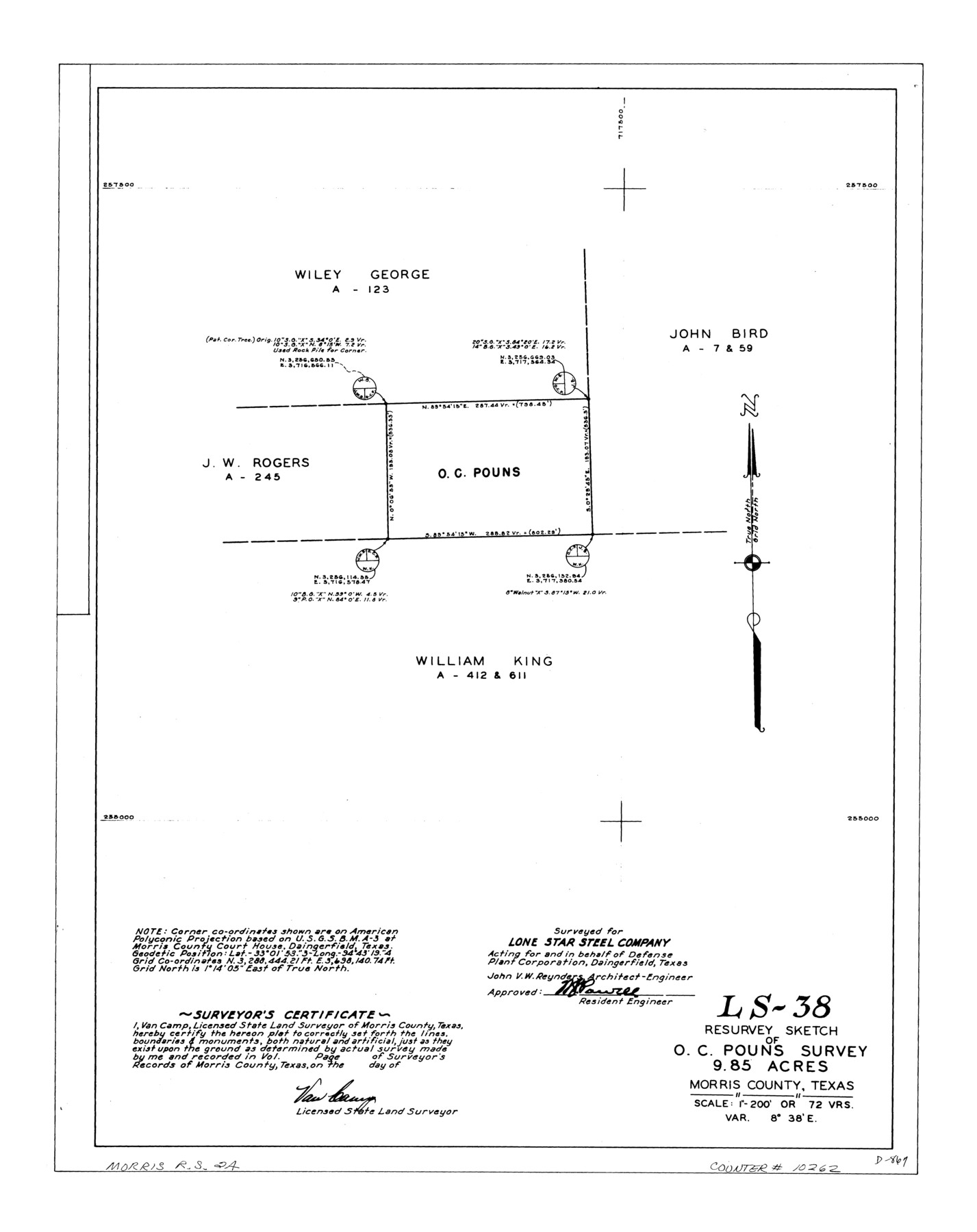
LS-38 - Resurvey sketch of O.C. Pouns survey, 9.85 acres, Morris County, Texas
-
Map/Doc
10262
-
Collection
General Map Collection
-
People and Organizations
Van Camp (Surveyor/Engineer)
-
Counties
Morris
-
Subjects
Surveying Rolled Sketch
-
Height x Width
24.4 x 19.3 inches
62.0 x 49.0 cm
-
Medium
linen, manuscript
-
Scale
1" = 72 varas
-
Comments
See Morris County Rolled Sketch 2 (9550) for map of all retracement surveys made for Lone Star Steel Company.
Related maps
Morris County Rolled Sketch 2

Print $40.00
- Digital $50.00
Morris County Rolled Sketch 2
1944
Size 59.4 x 43.5 inches
Map/Doc 9550
Part of: General Map Collection
Flight Mission No. BRE-1P, Frame 66, Nueces County

Print $20.00
- Digital $50.00
Flight Mission No. BRE-1P, Frame 66, Nueces County
1956
Size 18.5 x 22.4 inches
Map/Doc 86648
Washington County Working Sketch 2

Print $20.00
- Digital $50.00
Washington County Working Sketch 2
1981
Size 23.6 x 20.1 inches
Map/Doc 72363
Map and Profile No. 1 from the Red River to the Rio Grande; from explorations and surveys made under the direction of the Hon. Jefferson Davis, Secretary of War by Captain John Pope, Corps. Topl Engrs.

Print $40.00
- Digital $50.00
Map and Profile No. 1 from the Red River to the Rio Grande; from explorations and surveys made under the direction of the Hon. Jefferson Davis, Secretary of War by Captain John Pope, Corps. Topl Engrs.
Size 30.2 x 59.9 inches
Map/Doc 95176
Fort Bend County Working Sketch 26

Print $20.00
- Digital $50.00
Fort Bend County Working Sketch 26
1982
Size 18.5 x 23.6 inches
Map/Doc 69232

Bandera County Working Sketch 39

Print $20.00
- Digital $50.00
Bandera County Working Sketch 39
1975
Size 22.1 x 25.3 inches
Map/Doc 67635
Potter County Boundary File 1

Print $12.00
- Digital $50.00
Potter County Boundary File 1
Size 14.1 x 8.7 inches
Map/Doc 57937
Clay County Boundary File 9

Print $8.00
- Digital $50.00
Clay County Boundary File 9
Size 7.7 x 8.2 inches
Map/Doc 51393
Lavaca County Rolled Sketch 5

Print $40.00
- Digital $50.00
Lavaca County Rolled Sketch 5
Size 37.0 x 49.1 inches
Map/Doc 10288
Flight Mission No. CLL-3N, Frame 13, Willacy County

Print $20.00
- Digital $50.00
Flight Mission No. CLL-3N, Frame 13, Willacy County
1954
Size 18.4 x 22.1 inches
Map/Doc 87079
Jones County Rolled Sketch 1

Print $20.00
- Digital $50.00
Jones County Rolled Sketch 1
1957
Size 17.7 x 28.1 inches
Map/Doc 6451
Dickens County Working Sketch 10

Print $40.00
- Digital $50.00
Dickens County Working Sketch 10
1965
Size 62.2 x 39.5 inches
Map/Doc 68658
You may also like
Cherokee County Sketch File 9

Print $8.00
- Digital $50.00
Cherokee County Sketch File 9
1853
Size 5.6 x 4.2 inches
Map/Doc 18132
Cooke County Working Sketch 7

Print $20.00
- Digital $50.00
Cooke County Working Sketch 7
1939
Size 25.1 x 33.7 inches
Map/Doc 68244
Map of the United States engraved to illustrate Mitchell's new intermediate geography

Print $20.00
- Digital $50.00
Map of the United States engraved to illustrate Mitchell's new intermediate geography
1885
Size 12.2 x 18.5 inches
Map/Doc 93514
Nacogdoches County Working Sketch 13

Print $20.00
- Digital $50.00
Nacogdoches County Working Sketch 13
1912
Size 22.6 x 26.5 inches
Map/Doc 67086
Rusk County Sketch File 41

Print $20.00
Rusk County Sketch File 41
1951
Size 23.1 x 26.2 inches
Map/Doc 12277
Duval County Rolled Sketch 15

Print $20.00
- Digital $50.00
Duval County Rolled Sketch 15
1940
Size 38.7 x 27.1 inches
Map/Doc 5737
Jasper County Working Sketch 2

Print $20.00
- Digital $50.00
Jasper County Working Sketch 2
Size 18.6 x 22.5 inches
Map/Doc 66464
Calhoun County NRC Article 33.136 Sketch 2

Print $20.00
- Digital $50.00
Calhoun County NRC Article 33.136 Sketch 2
2002
Size 18.2 x 24.6 inches
Map/Doc 78653

Zavala County Sketch File 48

Print $6.00
- Digital $50.00
Zavala County Sketch File 48
1942
Size 11.4 x 9.0 inches
Map/Doc 41438
Kleberg County Rolled Sketch 10-1

Print $20.00
- Digital $50.00
Kleberg County Rolled Sketch 10-1
1951
Size 36.9 x 32.2 inches
Map/Doc 9383
Travis County State Real Property Sketch 8

Print $20.00
- Digital $50.00
Travis County State Real Property Sketch 8
1996
Size 30.5 x 42.6 inches
Map/Doc 77192